The El Niño—Southern Oscillation (ENSO) is an established climate pattern, and its impact shouldn't be disproportionately attributed to climate change.
null

Executive summary

  • Climate change isn't a new phenomenon, and its impact on annual expected insured losses, while trending upward, isn't fluctuating wildly — contrary to some perceptions in the market.
  • As an industry, we should adjust to the idea of thinking about climate change as a systemic risk and not overreacting to weather-related events in the short term.
  • The near-term impact of seasonal climate variability as driven by scientifically recognized weather patterns shouldn't be conflated with climate change.
  • Historically, El Niño years tends to see lower insured losses compared to La Niña years, globally and for Asia Pacific
  • Working closely with the catastrophe and climate specialists can identify and assess impacted risk exposures and help (re)insurers to manage them.

Climate change — the term which refers to long-term shifts in temperatures and weather patterns — has become a core focus of the (re)insurance industry in recent years, as carriers seek to better understand the impact of increased volatility around weather-driven natural catastrophe events.

Furthermore, it's important to understand that all territories in Asia Pacific are experiencing changes in exposure at risk, and that the main driver of increased natural catastrophe losses continues to be increased property values in at-risk locations.

It may surprise readers to learn that, after accounting for inflation, growth in exposure and increased insurance penetration, there's no definitive trend of change observed in NATCAT-related losses, correlated to climate change.

Instead, closer examination of the data reveals that the surge in loss frequency seen over the past few years is attributed, at least in part, to the well-recognized, recurring pattern of climate variability known as La Niña.

The “triple-dip” La Niña

La Niña conditions are historically attributed to higher climate-related insured losses, as the Gallagher Re loss database indicates (Figure 2). From 2020 to 2022, there was an unusually prolonged phase of three consecutive northern hemisphere winter years of La Niña — the so-called “triple-dip”. Other “triple-dip” La Niña phases recorded since 1950 occurred during 1998-2001, 1973-1976 and 1954-1956.

Whilst climate change is fundamentally long term with modest impact year-on-year, seasonal climate variability driven by patterns such as ENSO, Indian Ocean Dipole (IOD) and Madden-Julian Oscillation (MJO) has meaningful immediate and near-term effects (see What is ENSO and What are IOD and MJO, below). The risk landscape is complex and evolving and — long-term climate change’s compounding results notwithstanding — we believe immediate reinsurance discussions should be more focused on existing seasonal weather patterns, which have varying impact across perils and geographies.

El Niño is already here

In recent months, we've experienced the beginnings of a shift from La Niña to El Niño, as the previously weak El Niño conditions in the central-eastern equatorial Pacific have gradually strengthened to a weak-to-moderate El Niño.

The National Oceanic and Atmospheric Administration (NOAA) Climate Prediction Centre (CPC) issued an El Niño advisory in August 2023, indicating the presence of the warm phase of the ENSO. The CPC forecast indicates a greater than 95% chance that El Niño conditions will persist through the northern hemisphere autumn and winter, while weakening during the northern hemisphere spring of 2024.

Chances for El Nino are 60% or greater, while chances for La Nina are near zero.
Sea surface temperatures are for El Nino region are increasingly above average since June 2023.
Figure 1. Top: The CPC ENSO probabilistic forecast (September 14, 2023) showing that El Niño conditions have developed and are forecast to continue throughout the northern hemisphere winter. Source: National Oceanic and Atmospheric Administration (NOAA). Bottom: Monthly sea surface temperature anomalies for NINO3.4 region. Model run September 16, 2023. Source: Australia Bureau of Meteorology.

Sea surface temperatures (SSTs) in the tropical Pacific are exceeding El Niño thresholds, with climate models indicating this trend is likely to continue through the end of the year at least. Overall, signs are that the atmosphere is responding to the pattern of SSTs in the tropical Pacific, and coupling of the ocean and atmosphere has started to occur, which is a characteristic of an El Niño event. A positive IOD is also underway.

Losses are likely to reduce

In terms of global temperature, El Niño represents a release of heat energy stored in the oceans into space through the atmosphere, while La Niña represents an increase of heat stored in the oceans.

Therefore, El Niño years are typically the hottest years in the warming global temperature trend, which often fuels record-breaking extreme heat events on land, such as those we saw in the 2023 Northern Hemisphere summer. El Niño also brings a pivot in terms of physical loss, given the shift in rainfall patterns and general reduction in rainfall across the wider region.

Based on Gallagher Re’s database of insured losses between 1980 and 2022, climate-related peril losses during El Niño years are lower than La Niña years and neutral years, both globally and in the Asia Pacific.

While not always the case, a rapid swing from La Niña to El Niño can be quite uncertain, as regional weather patterns abruptly change from one extreme to another.

From 1980-2022, climate-related peril losses in El Niño years are less than La Niña years and neutral years, globally and in the Asia Pacific.
Figure 2. Average climate-related indexed losses only across 1980-2022 for neutral (21), La Niña (13), and El Niño (9) years with numbers in brackets indicate count. The Global losses are on the left-hand y-axis while the Asia Pacific losses are on the right-hand y-axis. Source: Arthur J. Gallagher & Co. data. Classification: Calendar-year average ENSO phase.

What is ENSO?

ENSO is a recurring pattern of climate variability of the tropical Pacific that has worldwide effects on seasonal weather and climate. It's split into three phases: El Niño (warm phase), neutral and La Niña (cool phase). ENSO arises from interactions between the atmosphere and the ocean across the Pacific and result in one of Earth’s largest and perhaps most influential inter-annual natural climate patterns.

El Niño conditions refer to sea surface temperatures (SSTs) in the eastern equatorial Pacific Ocean being relatively warmer and the equatorial trade winds being weaker, while the reverse is true for La Niña conditions. Neutral means that the temperatures, winds, convection and rainfall across the tropical Pacific are near their long-term averages. The Southern Oscillation refers primarily to the atmospheric component of the combined system and is typically measured through air pressure anomalies. The ENSO footprint historically had the greatest influence during the Northern Hemispheric winter months (December to March) and is most strongly felt in regions close to the Pacific Ocean.

Sea surface temperature anomalies
Figure 3. Sea surface temperature anomalies on September 18, 2023, showing El Niño conditions in the Pacific Ocean and warm waters in the Atlantic Ocean. Data: NOAA. Graphic: Arthur J. Gallagher & Co.

During La Niña, the cooler SSTs in the central and eastern tropical Pacific Ocean strengthen the easterly trade winds along the equator, while the already-warm SSTs to the north of Australia get warmer still. The opposite is true during El Niño, with SSTs in the central and eastern tropical Pacific Ocean becoming substantially warmer than average, causing the prevailing east-to-west equatorial trade winds to weaken or even reverse. This shift results in the central and eastern Pacific area becoming more favorable for tropical rainfall and cloud development.

The National Oceanic and Atmospheric Administration (NOAA) defines neutral ENSO conditions when three-monthly average SST anomalies in the eastern equatorial Pacific are between -0.5°C and +0.5°C in the Niño-3.4 region, with El Niño and La Niña conditions defined as being above and below this range, respectively.

But there are different ENSO definitions in other regions, with organizations such as the Australian Bureau of Meteorology (BoM) also including atmospheric Southern Oscillation components within its criteria for declaring whether El Niño or La Niña is in progress.

Anomalies in sea surface temperatures
Figure 4: Monthly sea surface temperature anomalies in the Pacific Ocean’s Niño-3.4 region dating from 1950 to 2022. Source: NOAA Climate Prediction Center.

What are IOD and MJO?

The Indian Ocean Dipole (IOD) and Madden-Julian Oscillation (MJO) are two other weather patterns that have meaningful immediate and near-term effects on particular regions.

The IOD, also known as the Indian Niño, can be very influential for countries bordering the Indian Ocean such as Australia, India and Southeast Asia. As with ENSO, it has three phases: warmer (positive), neutral and cooler (negative). Broadly speaking, the positive phase sees greater-than-average sea-surface temperatures and greater precipitation in the western Indian Ocean region, with a corresponding cooling of waters in the eastern Indian Ocean—which tends to cause droughts in adjacent land areas of Indonesia and Australia. The negative phase of the IOD brings about the opposite conditions, with warmer water and greater precipitation in the eastern Indian Ocean, and cooler and drier conditions in the west.

The MJO, a global-scale feature of the tropical atmosphere, meanwhile is an eastward moving disturbance of clouds, rainfall and winds between Singapore and Canton Island, which is characterized by an eastward spread of large regions of enhanced and suppressed tropical rainfall, mainly observed over the Indian and Pacific Ocean.

The enhanced rainfall phase of the MJO can also bring the onset of the Monsoon seasons around the globe. Conversely, the suppressed convection phase can delay the onset of the Monsoon season.

There is evidence that the MJO influences the ENSO cycle. While MJO doesn't cause El Niño or La Niña, it can contribute to the speed of development and intensity of El Niño and La Niña episodes. The MJO appears to be more active during neutral and weak ENSO years.

Effects across Asia Pacific

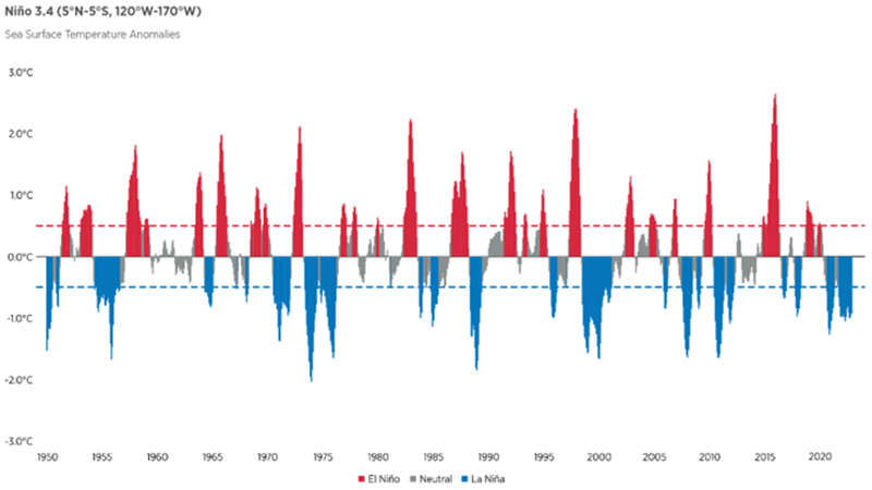
The maps below highlight observed weather patterns globally during El Niño and La Niña phases. Outcomes vary, depending on the intensity of the phase, the time of year it develops and the interaction with other climate patterns.

Broadly speaking, for Asia Pacific, La Niña is often associated with wet conditions in eastern Australia, and with heavy rainfall in Indonesia, the Philippines and Thailand.

El Niño meanwhile, is often associated with warm and dry conditions in southern and eastern inland areas of Australia, as well as Indonesia, the Philippines, Malaysia and central Pacific islands such as Fiji, Tonga and Papua New Guinea. During the northern hemisphere summer season, the Indian monsoon rainfall generally tends to be less than normal during El Niño phases.

Maps illustrate the information in preceding text.
Figure 5. Maps show how ENSO commonly affects Northern Hemisphere winter and summer climate patterns around the globe. Source: NOAA

Details regarding regional and country specific rainfall relationships with ENSO phases are detailed briefly in the following table and in more detail in the text. Because the interplay between the various climatic patterns is complex, it's important to identify their various phases to understand any offsetting effects.

Region El Niño La Niña IOD Phase
West North Pacific basin Tropical cyclones (TCs) form more south-easterly TCs form more north-westerly Positive: North Asia affected by TCs
Australia Reduced rainfall, possible droughts leading to increased risk of bushfires Increased rainfall, possibility of flood events Positive: Reduced rainfall, increase risk of bushfires

Negative: Increased rainfall
India Reduced rainfall during monsoon season Above-average rainfall during summer monsoon Positive: Increased rainfall

Negative: Reduced rainfall
China Increased rainfall in southern China and reduced in northern China Reduced rainfall in southern China and increased in northern China Asymmetric influence
Japan Increased rainfall in western Japan during summer Increased rainfall in Southwest Islands during summer
Southeast Asia (Malaysia, Indonesia, Philippines, Vietnam, Thailand, and Singapore) Reduced rainfall Increased rainfall Positive: Reduced rainfall in Indonesia. Increased rainfall in Vietnam

Negative: Increased rainfall in Indonesia
South Korea Increased rainfall Reduced rainfall

Western North Pacific Typhoon

  • In the Western North Pacific, El Niño phases correlate with higher typhoon frequencies across much of the basin. In general, the ENSO correlation with landfalling typhoon frequency in the Northwest Pacific is less than with Atlantic landfalling hurricanes, however storm formation often occurs more frequently in the seas east of Guam during El Niño phases, with increased incidence of recurved tracks towards the part of the basin closest to Japan.
  • El Niño conditions favor longer-lived and more intense storms, compared with La Niña conditions.
  • The IOD is currently in a positive phase, which is expected to last during the rest of the WNP Basin Typhoon season. Historically, a positive IOD has tended to lead to a recurving north-eastward track or a westward path south of 15°N, leading to more tropical cyclones (TCs) impacting Japan, South Korea or South Vietnam.

Australia

  • During La Niña events, rainfall north of Australia enhances and typically increases the chance of above-average rainfall for eastern, central and northern parts of Australia. Insured losses are typically higher for La Niña than El Niño in Australia.
  • During El Niño, the opposite is true. Rainfall is usually reduced through winter-spring in Australia, especially across eastern and northern areas.
  • Whether Australia experiences strong drought or fire weather conditions during El Nino is dependent upon two other drivers: the IOD and the Southern Annular Mode. These drivers are sometimes more important than ENSO: 2019-2020 was ENSO-neutral, yet Australia had record-breaking extreme fire weather and months of major fire events largely due to the other drivers.

India

  • ENSO impacts the arrival and strength of the Indian southwest monsoon, in part due to modification of the Walker Circulation – a Pacific-wide zonal circulation in tropical latitudes that affects convection over the equatorial Indian Ocean and consequently, rainfall over continental India. El Niño generally suppresses the southwest summer monsoon rainfall in India whereas it's often enhanced by La Niña. As a result, previous El Niño conditions have often coincided with droughts (e.g., 2002), whilst La Niña conditions have often coincided with above-average southwest monsoon rainfall, enhancing the potential for flood events.
  • A Gallagher Re investigation of available data indicates there is increased probability of hail occurrence in northeast India during the positive phase of ENSO. In northeast India, 86% of hail events between 1981 and 2015 occurred during periods with a positive ENSO index.
  • A positive IOD creates a conducive environment for tropical cyclones to form in the Indian Ocean.

China

  • Southern and East-Central China. Positive correlation between ENSO phase and autumn/winter rainfall in southern China. This positive correlation typically migrates eastward during the mature ENSO phase (often in winter) into southeastern China and then into eastern-central China during the spring. El Niño events often coincide with above-average autumn/winter rainfall in southern and southeastern China and above-average spring rainfall in eastern-central China.
  • Northern China. Negative correlation between ENSO phase and rainfall in northern China during the summer and autumn of the ENSO onset year. i.e., El Niño events often coincide with below-average rainfall in northern China during the early stages of the El Niño phase with limited correlation during El Niño decay.
  • Hong Kong. Generally wetter winters (December through February) and springs (March through May) during El Niño phase make it unlikely to have TCs affecting Hong Kong before June.

Rest of Asia Pacific

  • For Japan, El Niño effect leads to greater rainfall in the summer concentrated in western Japan, while increased rainfall in Southwest Islands during summer. The JMA predicts average to high rainfall in both western and eastern Japan this year between July and September. Generally cooler summer during El Niño and hotter summers during La Niña are observed.
  • For Southeast Asia, El Niño events tend to reduce overall rainfall, while La Niña years see increased rainfall in most regions. A positive IOD is associated with depressed rainfall.
  • For South Korea, El Niño leads to increase rainfall mainly in the southern region of the Korean Peninsula.

Managing the risks of climate variability

As outlined in the paper, the switch from La Niña to El Niño brings a pivot in terms of physical loss, since it correlates to warmer surface conditions. El Niño is associated with higher intensity of temperature extremes, shift in rainfall patterns and general reduction in rainfall across the wider region. And, as explained above, El Niño years tend to be lower for insured losses, compared with Neutral and La Niña years.

Whilst climate change is leading to variability in climate conditions and natural catastrophe events, this impact isn't pronounced in the next year or in the immediate future, butover the longer term.

In a changing world, being equipped with functional risk solutions to assess and quantify catastrophe risk is paramount. Gallagher Re’s team of catastrophe and climate specialists have best-in-class insight and understanding of the current and coming impacts of climate variability on the (re)insurance industry.

Working closely with the Gallagher Research Centre, our experts deploy the latest analytical expertise to identify and assess risk exposures in helping (re)insurers to manage them. With our presence across the Asia Pacific region, we harness our first-hand global and local knowledge, whilst leveraging our academic partners, to help clients navigate through weather and climate uncertainty.